|
|
Antenna Structure Registration 1032433 |
 |
Registration Info | Registration Number: 1032433 |
| File Number: A1063784 |
| Status: Constructed |
| Date Constructed: 01/01/1969 |
| FAA EMI: N |
| NEPA: N |
Structure Info
| Structure Type: TOWER |
| Structure Coordinates: 46-31-57.0 N 120-30-37.0 W (NAD 83) |
| Structure Coordinates: 46-31-57.5 N 120-30-32.8 W (Converted to NAD 27) |
| Structure Address: S13 T12n R13e Wm Ahtanum Ridge Rd 3.22 Km Sw Of Union Gap Nr |
| Structure City: Yakima, WA |
| Structure County: Yakima County |
| Painting & Lighting Info |
FCC Paragraph(s): 1, 3, 12, 21 |
| Elevation Info |
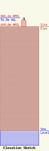
Site Elevation: 609.6 meters (2000 ft) |
| Height of Structure: 36.5 meters (120 feet) |
| Overall Height Above Ground: 51.5 meters (169 feet) |
| Overall Height Above Mean Sea Level: 661.1 meters (2169 feet) |
| Owner Info | Sinclair Yakima Licensee, LLC
Pillsbury Winthrop Shaw Pittman LLP
Washington, DC 20036
(202) 663-8195
miles.mason@pillsburylaw.com |
| Contact Info | Sinclair Yakima Licensee, LLC
Pillsbury Winthrop Shaw Pittman LLP
Washington, DC 20036
(202) 663-8195
miles.mason@pillsburylaw.com |
