|
|
Antenna Structure Registration 1059488 |
 |
Registration Info | Registration Number: 1059488 |
| File Number: A0615159 |
| FAA Study: 2002-AWP-3363-OE |
| FAA Issue Date: 10/28/2002 |
| Status: Dismantled |
| Date Constructed: 01/07/1999 |
| FAA EMI: N |
| NEPA: N |
Structure Info
| Structure Type: TOWER |
| Structure Coordinates: 32-53-13.2 N 109-18-51.4 W (NAD 83) |
| Structure Coordinates: 32-53-13.0 N 109-18-49.1 W (Converted to NAD 27) |
| Structure Address: Guthrie Peak, Ten Miles South Of Clifton |
| Structure City: Clifton, AZ |
| Structure County: Greenlee County |
| Painting & Lighting Info |
FAA Chapters: NONE |
Remarks: PRIOR STUDY 1998-AWP-3257-OE |
| Elevation Info |
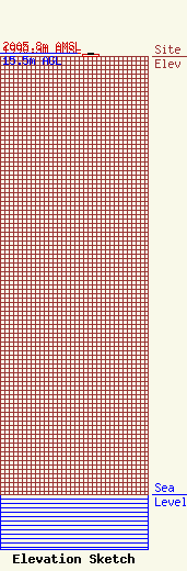
Site Elevation: 1990.3 meters (6530 ft) |
| Height of Structure: 12.5 meters (41 feet) |
| Overall Height Above Ground: 15.5 meters (51 feet) |
| Overall Height Above Mean Sea Level: 2005.8 meters (6581 feet) |
| Owner Info | Crown Communication Inc.
2000 Corporate Drive
Canonsburg, PA 15317
(724) 416-2000
Monica.Gambino@Crowncastle.com |
| Contact Info | Crown Castle USA Inc.
2000 Corporate Drive
Canonsburg, PA 15317
Monica Gambino
(724) 416-2516
Monica.Gambino@Crowncastle.com |
