|
|
Antenna Structure Registration 1025842 |
 |
Registration Info | Registration Number: 1025842 |
| File Number: A1262874 |
| FAA Study: 2022-ACE-8066-OE |
| FAA Issue Date: 01/19/2023 |
| Status: Constructed |
| Date Constructed: 12/01/1994 |
| NEPA: N |
Structure Info
| Structure Type: GTOWER |
| Structure Coordinates: 40-35-46.5 N 98-20-40.2 W (NAD 83) |
| Structure Coordinates: 40-35-46.5 N 98-20-39.0 W (Converted to NAD 27) |
| Structure Address: 2220 E 12th St (98532) |
| Structure City: Hastings, NE |
| Structure County: Adams County |
| Painting & Lighting Info |
FAA Circular #: 70/7460-1H |
FAA Chapters: 4, 6, 13 |
Remarks: PRIOR STUDY 2004-ACE-793-OE |
Remarks: OM&L to remain the same as prior study = 24-HR MED-STROBES |
Remarks: PRIOR STUDY 2004-ACE-793-OE |
Remarks: OM&L to remain the same as prior study = 24-HR MED-STROBES |
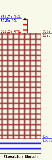
| Elevation Info |
Site Elevation: 581.2 meters (1907 ft) |
| Height of Structure: 76.2 meters (250 feet) |
| Overall Height Above Ground: 80.5 meters (264 feet) |
| Overall Height Above Mean Sea Level: 661.7 meters (2171 feet) |
| Owner Info | American Towers LLC
10 Presidential Way
Woburn, MA 01801
(781) 926-4500
faa-fcc@americantower.com |
| Contact Info | American Towers LLC
10 Presidential Way
Woburn, MA 01801
(781) 926-4500
faa-fcc@americantower.com |
