|
|
Antenna Structure Registration 1251439 |
 |
Registration Info | Registration Number: 1251439 |
| File Number: A1217034 |
| FAA Study: 2005-ACE-2635-OE |
| FAA Issue Date: 10/19/2005 |
| Status: Constructed |
| Date Constructed: 02/12/2007 |
| FAA EMI: N |
| NEPA: N |
Structure Info
|
| Structure Coordinates: 38-52-37.0 N 101-44-57.6 W (NAD 83) |
| Structure Coordinates: 38-52-37.0 N 101-44-56.0 W (Converted to NAD 27) |
| Structure Address: 1.5 Miles South Of Sharon Springs, Ks |
| Structure City: Sharon Springs, KS |
| Structure County: Wallace County |
| Painting & Lighting Info |
FAA Circular #: 70/7460-1K |
FAA Chapters: 4, 8, 12 |
Remarks: Removed expiration date from determination. Scenario 1./jjs/case#635066 |
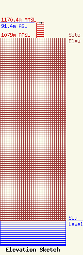
| Elevation Info |
Site Elevation: 1079 meters (3540 ft) |
| Height of Structure: 91.4 meters (300 feet) |
| Overall Height Above Ground: 91.4 meters (300 feet) |
| Overall Height Above Mean Sea Level: 1170.4 meters (3840 feet) |
| Owner Info | Nex-Tech Wireless, LLC
3001 New Way
Hays, KS 67601
(785) 621-3600
towers@ntwls.com |
| Contact Info | Nex-Tech Wireless, LLC
3001 New Way
Hays, KS 67601
Creighton Remus
(785) 621-3600
towers@ntwls.com |
