|
|
Antenna Structure Registration 1325437 |
 |
Registration Info | Registration Number: 1325437 |
| File Number: A1328023 |
| FAA Study: 1996-ANM-851-OE |
| FAA Issue Date: 10/17/1996 |
| Status: Constructed |
| Date Constructed: 05/26/2025 |
Structure Info
| Structure Type: GTOWER |
| Structure Coordinates: 43-14-5.4 N 123-19-24.2 W (NAD 83) |
| Structure Coordinates: 43-14-06.0 N 123-19-19.9 W (Converted to NAD 27) |
| Structure Address: Tower North Of 138 |
| Structure City: Roseburg, OR |
| Structure County: Douglas County |
| Painting & Lighting Info |
FAA Chapters: NONE |
| Elevation Info |
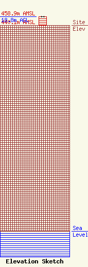
Site Elevation: 440.1 meters (1444 ft) |
| Height of Structure: 18.8 meters (62 feet) |
| Overall Height Above Ground: 18.8 meters (62 feet) |
| Overall Height Above Mean Sea Level: 458.9 meters (1506 feet) |
| Owner Info | Cagle Communications Inc.
2141 NE Airport Road, Ste 9
Roseburg, OR 97470
(541) 672-1233
johnl@caglecommunications.com |
| Contact Info | Cagle Communications Inc.
2141 NE Airport Road, Ste 9
Roseburg, OR 97470
(541) 672-1233
johnl@caglecommunications.com |
