|
|
Antenna Structure Registration 1025336 |
 |
Registration Info | Registration Number: 1025336 |
| File Number: A0030071 |
| FAA Study: 84-ACE-988-OE |
| FAA Issue Date: 07/11/1985 |
| Status: Constructed |
| Date Constructed: 01/01/1952 |
| NEPA: N |
Structure Info
| Structure Type: TOWER |
| Structure Coordinates: 42-27-44.0 N 99-52-20.0 W (NAD 83) |
| Structure Coordinates: 42-27-44.0 N 99-52-18.5 W (Converted to NAD 27) |
| Structure Address: On Hwy 7 6 Mi S |
| Structure City: Ainsworth, NE |
| Structure County: Brown County |
| Painting & Lighting Info |
FCC Paragraph(s): 1, 3, 12, 21 |
Remarks: RED LIGHTS/PAINT |
| Elevation Info |
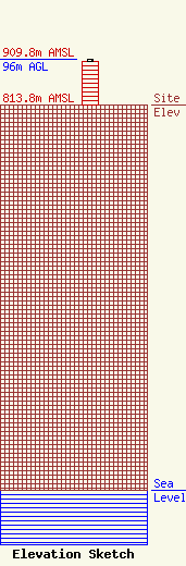
Site Elevation: 813.8 meters (2670 ft) |
| Height of Structure: 91.4 meters (300 feet) |
| Overall Height Above Ground: 96 meters (315 feet) |
| Overall Height Above Mean Sea Level: 909.8 meters (2985 feet) |
| Owner Info | KBR RURAL PUBLIC POWER DISTRICT
374 N PINE ST
187
AINSWORTH, NE 69210
(402) 387-1120
|
