|
|
Antenna Structure Registration 1309240 |
 |
Registration Info | Registration Number: 1309240 |
| File Number: A1344725 |
| FAA Study: 2018-ACE-6433-OE |
| FAA Issue Date: 09/17/2018 |
| Status: Constructed |
| Date Constructed: 06/27/2019 |
Structure Info
| Structure Type: LTOWER |
| Structure Coordinates: 41-54-24.9 N 92-53-59.9 W (NAD 83) |
| Structure Coordinates: 41-54-24.9 N 92-53-59.2 W (Converted to NAD 27) |
| Structure Address: 310th Street |
| Structure City: Laurel, IA |
| Structure County: Marshall County |
| Painting & Lighting Info |
FAA Circular #: 70/7460-1L |
FAA Chapters: 4, 8, 12 |
Remarks: Removed expiration date from determination. Scenario 1./jjs/case#635066 |
| Elevation Info |
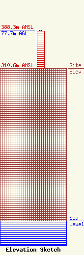
Site Elevation: 310.6 meters (1019 ft) |
| Height of Structure: 76.2 meters (250 feet) |
| Overall Height Above Ground: 77.7 meters (255 feet) |
| Overall Height Above Mean Sea Level: 388.3 meters (1274 feet) |
| Owner Info | Vertical Bridge Development, LLC
22 W Atlantic Avenue
Delray Beach, FL 33444
(561) 406-4015
fcc-faa@verticalbridge.com |
| Contact Info | Vertical Bridge Development, LLC
22 W Atlantic Avenue
Delray Beach, FL 33444
Richard Hickey
(561) 406-4015
fcc-faa@verticalbridge.com |
