|
|
Antenna Structure Registration 1045372 |
 |
Registration Info | Registration Number: 1045372 |
| File Number: A1376827 |
| FAA Study: 2020-AWP-10751-OE |
| FAA Issue Date: 09/28/2020 |
| Status: Constructed |
| Date Constructed: 10/20/2020 |
| NEPA: N |
Structure Info
| Structure Type: LTOWER |
| Structure Coordinates: 34-36-44.1 N 117-17-32.7 W (NAD 83) |
| Structure Coordinates: 34-36-44.1 N 117-17-29.5 W (Converted to NAD 27) |
| Structure Address: Quartzite Mountain, 3 Mi E Of Orogrande |
| Structure City: Victorville, CA |
| Structure County: San Bernardino County |
| Painting & Lighting Info |
FAA Chapters: NONE |
Remarks: PRIOR STUDY 1990-AWP-366-OE |
| Elevation Info |
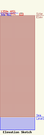
Site Elevation: 1329 meters (4360 ft) |
| Height of Structure: 30 meters (98 feet) |
| Overall Height Above Ground: 30 meters (98 feet) |
| Overall Height Above Mean Sea Level: 1359 meters (4459 feet) |
| Owner Info | K-LOVE, Inc.
2000 Reams Fleming Boulevard
Franklin, TN 37064
(916) 251-1600
fccdocumentdistribution@emfbroadcasting.com |
| Contact Info | K-LOVE, Inc.
2000 Reams Fleming Boulevard
Franklin, TN 37064
(916) 251-1600
fccdocumentdistribution@emfbroadcasting.com |
