|
|
Antenna Structure Registration 1218795 |
 |
Registration Info | Registration Number: 1218795 |
| File Number: A0222618 |
| FAA Study: 00-asw-1069-oe |
| FAA Issue Date: 04/28/2000 |
| Status: Constructed |
| Date Constructed: 10/29/2000 |
| FAA EMI: N |
| NEPA: N |
Structure Info
| Structure Type: TOWER |
| Structure Coordinates: 34-28-35.2 N 104-21-26.9 W (NAD 83) |
| Structure Coordinates: 34-28-35.0 N 104-21-25.0 W (Converted to NAD 27) |
| Structure Address: 6 Mi West Of Ft. Sumner, Nm |
| Structure City: Ft. Sumner, NM |
| Structure County: De Baca County |
| Painting & Lighting Info |
FAA Circular #: 70/7460-1K |
FAA Chapters: 3, 4, 5, 12 |
Remarks: Removed expiration date from determination. Scenario 1./jjs/case#635066 |
| Elevation Info |
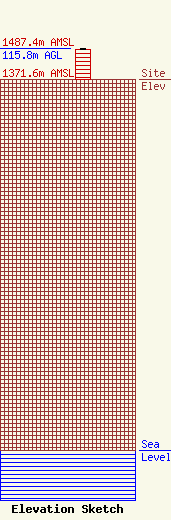
Site Elevation: 1371.6 meters (4500 ft) |
| Height of Structure: 109.7 meters (360 feet) |
| Overall Height Above Ground: 115.8 meters (380 feet) |
| Overall Height Above Mean Sea Level: 1487.4 meters (4880 feet) |
| Owner Info | Steele Electronics
Hc 64 box 112a
Ft. Sumner, NM 88119
Joseph Steele
(505) 355-7620
kb5zfa@etsc.net |
