|
|
Antenna Structure Registration 1051045 |
 |
Registration Info | Registration Number: 1051045 |
| File Number: A0816729 |
| FAA Study: 2004-AWP-2873-OE |
| FAA Issue Date: 07/22/2004 |
| Status: Constructed |
| Date Constructed: 01/01/1992 |
| FAA EMI: N |
| NEPA: N |
Structure Info
| Structure Type: TOWER |
| Structure Coordinates: 38-24-21.6 N 122-6-32.4 W (NAD 83) |
| Structure Coordinates: 38-24-21.9 N 122-06-28.5 W (Converted to NAD 27) |
| Structure Address: Mount Vaca, Top Of Mix Canyon Rd (vaca North #8502) |
| Structure City: Suisun City, CA |
| Structure County: Solano County |
| Painting & Lighting Info |
FAA Chapters: NONE |
Remarks: Removed expiration date from determination. Scenario 1./jjs/case#635066 |
Remarks: PRIOR STUDY 2004-AWP-1744-OE |
Remarks: Removed expiration date from determination. Scenario 1./jjs/case#635066 |
Remarks: PRIOR STUDY 2004-AWP-1744-OE |
| Elevation Info |
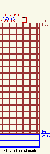
Site Elevation: 822 meters (2697 ft) |
| Height of Structure: 36.6 meters (120 feet) |
| Overall Height Above Ground: 42.7 meters (140 feet) |
| Overall Height Above Mean Sea Level: 864.7 meters (2837 feet) |
| Owner Info | American Towers LLC
10 Presidential Way
Woburn, MA 01801
(678) 564-3236
faa-fcc@americantower.com |
| Contact Info | American Towers, LLC.
10 Presidential Way
Woburn, MA 01801
(678) 564-3236
faa-fcc@americantower.com |
