|
|
Antenna Structure Registration 1053361 |
 |
Registration Info | Registration Number: 1053361 |
| File Number: A1089980 |
| FAA Study: 2017-ASW-1003-OE |
| FAA Issue Date: 02/14/2017 |
| Status: Constructed |
| Date Constructed: 10/01/2017 |
| NEPA: N |
Structure Info
| Structure Type: GTOWER |
| Structure Coordinates: 32-5-11.0 N 102-17-12.0 W (NAD 83) |
| Structure Coordinates: 32-05-10.6 N 102-17-10.5 W (Converted to NAD 27) |
| Structure Address: 3 Mi N Of Int Fm 1788 & Tx 158 |
| Structure City: Gardendale, TX |
| Structure County: Midland County |
| Painting & Lighting Info |
FAA Circular #: 70/7460-1L |
FAA Chapters: 3, 4, 5, 12 |
Remarks: PRIOR STUDY 1998-ASW-4097-OE |
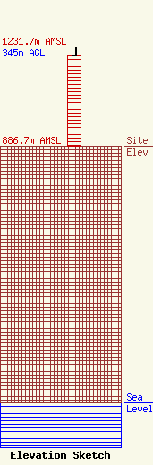
| Elevation Info |
Site Elevation: 886.7 meters (2909 ft) |
| Height of Structure: 314 meters (1030 feet) |
| Overall Height Above Ground: 345 meters (1132 feet) |
| Overall Height Above Mean Sea Level: 1231.7 meters (4041 feet) |
| Owner Info | Subcarrier Communications Inc
139 White Oak Lane
Old Bridge, NJ 08857
(732) 607-2828
subcom1@subcarrier.com |
| Contact Info | Subcarrier Communications Inc
139 White Oak Lane
Old Bridge, NJ 08857
John Paleski
(732) 607-2828
subcom1@subcarrier.com |
