|
|
Antenna Structure Registration 1058261 |
 |
Registration Info | Registration Number: 1058261 |
| File Number: A1230548 |
| FAA Study: 98-ASW-3516-OE |
| FAA Issue Date: 09/11/1998 |
| Status: Granted |
| Date Constructed: 06/01/1956 |
| FAA EMI: N |
| NEPA: N |
Structure Info
|
| Structure Coordinates: 31-50-53.0 N 102-27-5.0 W (NAD 83) |
| Structure Coordinates: 31-50-52.5 N 102-27-03.5 W (Converted to NAD 27) |
| Structure Address: 2413 North Alturas Ave |
| Structure City: Odessa, TX |
| Structure County: Ector County |
| Painting & Lighting Info |
FCC Paragraph(s): 1, 3, 4, 13, 21 |
Remarks: OM&L TO REMAIN RED LIGHTS/PAINT. |
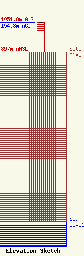
| Elevation Info |
Site Elevation: 897 meters (2943 ft) |
| Height of Structure: 153.8 meters (505 feet) |
| Overall Height Above Ground: 154.8 meters (508 feet) |
| Overall Height Above Mean Sea Level: 1051.8 meters (3451 feet) |
| Owner Info | Andrews Tower Rental Inc.
400 County Road 174
Brownwood, TX 76801
(325) 200-9118
krmcmillan78@yahoo.com |
| Contact Info | Andrews Tower Rental Inc.
400 County Road 174
Brownwoo, TX 76801
Karen McMillan
(325) 200-9118
krmcmillan78@yahoo.com |
