|
|
Antenna Structure Registration 1271533 |
 |
Registration Info | Registration Number: 1271533 |
| File Number: A1276384 |
| FAA Study: 2009-ANM-988-OE |
| FAA Issue Date: 07/02/2009 |
| Status: Constructed |
| Date Constructed: 11/07/2010 |
| FAA EMI: N |
| NEPA: N |
Structure Info
|
| Structure Coordinates: 40-32-46.9 N 105-11-54.8 W (NAD 83) |
| Structure Coordinates: 40-32-47.0 N 105-11-52.9 W (Converted to NAD 27) |
| Structure Address: Soderburg Communications Site |
| Structure City: Fort Collins, CO |
| Structure County: Larimer County |
| Painting & Lighting Info |
FAA Chapters: NONE |
Remarks: Removed expiration date from determination. Scenario 1./jjs/case#635066 |
| Elevation Info |
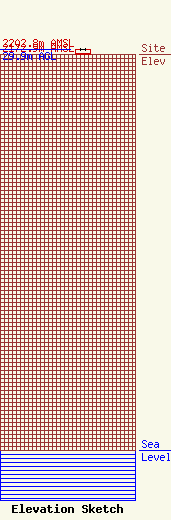
Site Elevation: 2172.9 meters (7129 ft) |
| Height of Structure: 27.7 meters (91 feet) |
| Overall Height Above Ground: 29.9 meters (98 feet) |
| Overall Height Above Mean Sea Level: 2202.8 meters (7227 feet) |
| Owner Info | RF Towers, LLC
1418 Bradley Avenue
Cheyenne, WY 82001
(307) 772-1322
vicmichael@RF-Towers.com |
| Contact Info | RF Towers, LLC
1418 Bradley Avenue
Cheyenne, WY 82001
Victor Michael
(307) 772-1322
vicmichael@RF-Towers.com |
