|
|
Antenna Structure Registration 1002191 |
 |
Registration Info | Registration Number: 1002191 |
| File Number: A0428978 |
| FAA Study: 80-ARM-263-OE |
| FAA Issue Date: 08/19/1980 |
| Status: Constructed |
| Date Constructed: 07/01/1981 |
| FAA EMI: N |
| NEPA: N |
Structure Info
| Structure Type: TOWER |
| Structure Coordinates: 47-46-25.0 N 114-16-7.0 W (NAD 83) |
| Structure Coordinates: 47-46-25.2 N 114-16-03.6 W (Converted to NAD 27) |
| Structure Address: Atop Mountain Peak 3.2 Km Se |
| Structure City: Big Arm, MT |
| Structure County: Lake County |
| Painting & Lighting Info |
FCC Paragraph(s): 1, 3, 4, 13, 21 |
Remarks: RED LIGHTS/PAINT |
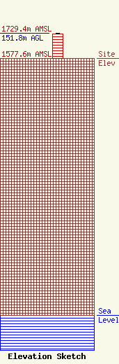
| Elevation Info |
Site Elevation: 1577.6 meters (5176 ft) |
| Height of Structure: 150.9 meters (495 feet) |
| Overall Height Above Ground: 151.8 meters (498 feet) |
| Overall Height Above Mean Sea Level: 1729.4 meters (5674 feet) |
| Owner Info | Anderson Radio Broadcasting Company
581 N Eservoir Rd
Polson, MT 30009
(406) 883-5255
|
