|
|
Antenna Structure Registration 1302668 |
 |
Registration Info | Registration Number: 1302668 |
| File Number: A1075097 |
| FAA Study: 2017-AAL-34-OE |
| FAA Issue Date: 03/06/2017 |
| Status: Granted |
Structure Info
| Structure Type: POLE |
| Structure Coordinates: 59-3-53.2 N 160-25-24.0 W (NAD 83) |
| Structure Coordinates: 59-03-56.0 N 160-25-16.0 W (Converted to NAD 27) |
| Structure Address: 18035' Bearing Of 61 Deg. From The Int. Of Togiak Height Rd. & Salmonberry Rd. |
| Structure City: Togiak, AK |
| Structure County: Dillingham Census Area |
| Painting & Lighting Info |
FAA Chapters: NONE |
Remarks: Removed expiration date from determination. Scenario 1./jjs/case#635066 |
| Elevation Info |
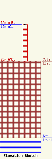
Site Elevation: 25 meters (82 ft) |
| Height of Structure: 12 meters (39 feet) |
| Overall Height Above Ground: 12 meters (39 feet) |
| Overall Height Above Mean Sea Level: 37 meters (121 feet) |
| Owner Info | Chignik Radio Association, Inc.
474
Nenana, AK 99760
(503) 504-9862
art@vfcm.org |
| Contact Info | Sterling Communications, Inc.
219 Dodd Rd.
Ringgold, GA 30736
Charles Burkhart
(706) 965-2355
sterling@catt.com |
