|
|
Antenna Structure Registration 1031207 |
 |
Registration Info | Registration Number: 1031207 |
| File Number: A1171577 |
| FAA Study: 2019-AWP-2428-OE |
| FAA Issue Date: 04/18/2019 |
| Status: Constructed |
| Date Constructed: 12/08/1983 |
| NEPA: N |
Structure Info
| Structure Type: GTOWER |
| Structure Coordinates: 32-40-48.0 N 115-25-38.0 W (NAD 83) |
| Structure Coordinates: 32-40-47.8 N 115-25-35.0 W (Converted to NAD 27) |
| Structure Address: 1222 E Carr Rd |
| Structure City: Calexico, CA |
| Structure County: Imperial County |
| Painting & Lighting Info |
FAA Circular #: 70/7460-1L |
FAA Chapters: 4, 8, 12 |
Remarks: PRIOR STUDY 1995-AWP-612-OE |
| Elevation Info |
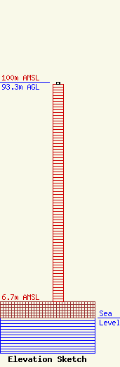
Site Elevation: 6.7 meters (22 ft) |
| Height of Structure: 92.4 meters (303 feet) |
| Overall Height Above Ground: 93.3 meters (306 feet) |
| Overall Height Above Mean Sea Level: 100 meters (328 feet) |
| Owner Info | TowerCo IV LLC
5000 Valleystone Drive, Suite 200
Cary, NC 27519
(919) 653-5742
cdoherty@towerco.com |
| Contact Info | TowerCo IV LLC
5000 Valleystone Drive, Suite 200
Cary, NC 27519
Chad Doherty
(919) 653-5742
cdoherty@towerco.com |
