|
|
Antenna Structure Registration 1227936 |
 |
Registration Info | Registration Number: 1227936 |
| File Number: A1091957 |
| FAA Study: 01-ASW-3262-OE |
| FAA Issue Date: 06/25/2001 |
| Status: Constructed |
| Date Constructed: 08/15/2001 |
| FAA EMI: N |
| NEPA: N |
Structure Info
|
| Structure Coordinates: 36-58-34.4 N 101-48-42.9 W (NAD 83) |
| Structure Coordinates: 36-58-34.3 N 101-48-41.3 W (Converted to NAD 27) |
| Structure Address: 1.25 Miles South Of Elkhart Ks On Road C, 5 Miles East, 1/2mile North |
| Structure City: Elkhart, OK |
| Structure County: Texas County |
| Painting & Lighting Info |
FAA Circular #: 70/7460-1K |
FAA Chapters: 4, 6, 12 |
Remarks: Removed expiration date from determination. Scenario 1./jjs/case#635066 |
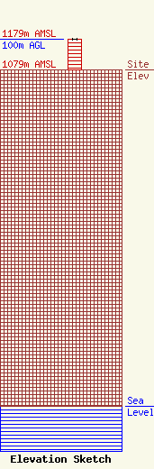
| Elevation Info |
Site Elevation: 1079 meters (3540 ft) |
| Height of Structure: 100 meters (328 feet) |
| Overall Height Above Ground: 100 meters (328 feet) |
| Overall Height Above Mean Sea Level: 1179 meters (3868 feet) |
| Owner Info | G & G ELECTRONICS, INC.
102 North Main Street
Guymon, OK 73942
(580) 338-7763
ggelecg@gmail.com |
| Contact Info | G & G ELECTRONICS, INC.
102 NORTH MAIN STREET
GUYMON, OK 73942
MARY SELL
(580) 338-7763
ggelecg@gmail.com |
