|
|
Antenna Structure Registration 1048201 |
 |
Registration Info | Registration Number: 1048201 |
| File Number: A1308071 |
| FAA Study: 2025-ASW-1569-OE |
| FAA Issue Date: 02/12/2025 |
| Status: Constructed |
| Date Constructed: 01/01/1982 |
| NEPA: N |
Structure Info
| Structure Type: GTOWER |
| Structure Coordinates: 30-22-43.7 N 95-31-41.9 W (NAD 83) |
| Structure Coordinates: 30-22-43.0 N 95-31-41.1 W (Converted to NAD 27) |
| Structure Address: 8400 Longmire Rd. (conroe/league Line Rd 1 #004066) |
| Structure City: Conroe, TX |
| Structure County: Montgomery County |
| Painting & Lighting Info |
FAA Circular #: 70/7460-1J |
FAA Chapters: 3, 4, 5, 13 |
Remarks: PRIOR STUDY 2004-ASW-4824-OE |
Remarks: OM&L to remain the same as prior study = PAINT/RED LIGHTS |
Remarks: PRIOR STUDY 2004-ASW-4824-OE |
Remarks: OM&L to remain the same as prior study = PAINT/RED LIGHTS |
| Elevation Info |
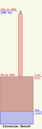
Site Elevation: 99.1 meters (325 ft) |
| Height of Structure: 176.8 meters (580 feet) |
| Overall Height Above Ground: 185 meters (607 feet) |
| Overall Height Above Mean Sea Level: 284.1 meters (932 feet) |
| Owner Info | American Towers LLC
10 Presidential Way
Woburn, MA 01801
(781) 926-4500
faa-fcc@americantower.com |
| Contact Info | American Towers LLC
10 Presidential Way
Woburn, MA 01801
(781) 926-4500
faa-fcc@americantower.com |
