|
|
Antenna Structure Registration 1315006 |
 |
Registration Info | Registration Number: 1315006 |
| File Number: A1168939 |
| FAA Study: 2020-ACE-3425-OE |
| FAA Issue Date: 06/12/2020 |
| Status: Granted |
Structure Info
| Structure Type: GTOWER |
| Structure Coordinates: 37-39-9.8 N 98-44-33.3 W (NAD 83) |
| Structure Coordinates: 37-39-09.7 N 98-44-32.0 W (Converted to NAD 27) |
| Structure Address: 201 Simpson Street |
| Structure City: Pratt, KS |
| Structure County: Pratt County |
| Painting & Lighting Info |
FCC Paragraph(s): 1, 3, 11, 21 |
Remarks: Continue As Is OM&L = PAINT/RED LIGHTS |
| Elevation Info |
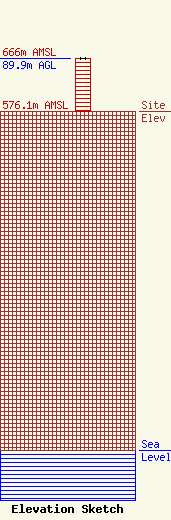
Site Elevation: 576.1 meters (1890 ft) |
| Height of Structure: 89.9 meters (295 feet) |
| Overall Height Above Ground: 89.9 meters (295 feet) |
| Overall Height Above Mean Sea Level: 666 meters (2185 feet) |
| Owner Info | D & R Trucking
201 Simpson Street
Pratt, KS 67214-9906
(620) 672-7713
dandrtruck1@gmail.com |
| Contact Info | D & R Trucking
201 Simpson Street
Pratt, KS 67214-9906
Cletus Gamblin
(620) 672-7713
dandrtruck1@gmail.com |
