|
|
Antenna Structure Registration 1033503 |
 |
Registration Info | Registration Number: 1033503 |
| File Number: A1387991 |
| FAA Study: 2026-ACE-1968-OE |
| FAA Issue Date: 05/11/2026 |
| Status: Constructed |
| Date Constructed: 01/01/1992 |
| NEPA: N |
Structure Info
| Structure Type: GTOWER |
| Structure Coordinates: 39-23-20.0 N 97-6-49.0 W (NAD 83) |
| Structure Coordinates: 39-23-20.0 N 97-06-47.9 W (Converted to NAD 27) |
| Structure Address: .5 Mi E |
| Structure City: Clay Center, KS |
| Structure County: Clay County |
| Painting & Lighting Info |
FAA Circular #: 70/7460-1M |
FAA Chapters: 4, 8, 15 |
Remarks: OM&L to remain the same as prior study = A MED-DUAL SYSTEM |
Remarks: PRIOR STUDY 2022-ACE-8863-OE |
Remarks: OM&L to remain the same as prior study = A MED-DUAL SYSTEM |
Remarks: PRIOR STUDY 2022-ACE-8863-OE |
| Elevation Info |
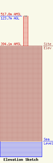
Site Elevation: 394.1 meters (1293 ft) |
| Height of Structure: 123.7 meters (406 feet) |
| Overall Height Above Ground: 123.7 meters (406 feet) |
| Overall Height Above Mean Sea Level: 517.8 meters (1699 feet) |
| Owner Info | CTI Towers Assets, II, LLC c/o Symphony Towers Infrastructure
44 South Broadway
44 South Broadway
White Plains, NY 10601
(919) 893-2841
ccooper@symphonyinfra.com |
| Contact Info | CTI Towers Assets, II, LLC c/o Symphony Towers Infrastructure
44 South Broadway
44 South Broadway
White Plains, NY 10601
Christine Cooper
(919) 893-2841
ccooper@symphonyinfra.com |
