|
|
Antenna Structure Registration 1041578 |
 |
Registration Info | Registration Number: 1041578 |
| File Number: A1342540 |
| FAA Study: 2017-ANM-284-OE |
| FAA Issue Date: 03/14/2017 |
| Status: Constructed |
| Date Constructed: 01/01/1989 |
| NEPA: N |
Structure Info
| Structure Type: GTOWER |
| Structure Coordinates: 44-0-9.5 N 123-6-48.6 W (NAD 83) |
| Structure Coordinates: 44-00-10.1 N 123-06-44.3 W (Converted to NAD 27) |
| Structure Address: 4565 Blanton Rd (us-or-5012) |
| Structure City: Eugene, OR |
| Structure County: Lane County |
| Painting & Lighting Info |
FAA Circular #: 70/7460-1L |
FAA Chapters: 4, 8, 12 |
Remarks: Removed expiration date from determination. Scenario 1./jjs/case#635066 |
| Elevation Info |
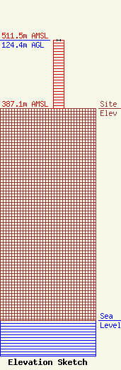
Site Elevation: 387.1 meters (1270 ft) |
| Height of Structure: 124.4 meters (408 feet) |
| Overall Height Above Ground: 124.4 meters (408 feet) |
| Overall Height Above Mean Sea Level: 511.5 meters (1678 feet) |
| Owner Info | VB-S1 Assets, LLC
22 W Atlantic Avenue
Delray Beach, FL 33444
(561) 406-4015
fcc-faa@verticalbridge.com |
| Contact Info | VB-S1 Assets, LLC
22 W Atlantic Avenue
Delray Beach, FL 33444
Richard Hickey
(561) 406-4015
fcc-faa@verticalbridge.com |
