|
|
Antenna Structure Registration 1011467 |
 |
Registration Info | Registration Number: 1011467 |
| File Number: A0611173 |
| FAA Study: 83-ASW-995-OE |
| FAA Issue Date: 05/10/1983 |
| Status: Constructed |
| Date Constructed: 05/01/1958 |
| FAA EMI: N |
| NEPA: N |
Structure Info
| Structure Type: TOWER |
| Structure Coordinates: 36-34-55.0 N 98-52-13.0 W (NAD 83) |
| Structure Coordinates: 36-34-54.9 N 98-52-11.7 W (Converted to NAD 27) |
| Structure Address: 400 S Lincoln .25 Mi E |
| Structure City: Waynoka, OK |
| Structure County: Woods County |
| Painting & Lighting Info |
FCC Paragraph(s): 1, 3, 12, 21 |
Remarks: RED LIGHTS/PAINT |
| Elevation Info |
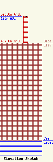
Site Elevation: 467.8 meters (1535 ft) |
| Height of Structure: 128 meters (420 feet) |
| Overall Height Above Ground: 128 meters (420 feet) |
| Overall Height Above Mean Sea Level: 595.8 meters (1955 feet) |
| Info |
| Info |
