|
|
Antenna Structure Registration 1061509 |
 |
Registration Info | Registration Number: 1061509 |
| File Number: A1048557 |
| FAA Study: 2016-AWP-6470-OE |
| FAA Issue Date: 08/03/2016 |
| Status: Constructed |
| Date Constructed: 09/01/1992 |
| NEPA: N |
Structure Info
| Structure Type: LTOWER |
| Structure Coordinates: 33-6-40.0 N 117-12-8.0 W (NAD 83) |
| Structure Coordinates: 33-06-39.9 N 117-12-04.9 W (Converted to NAD 27) |
| Structure Address: 1510 La Plaza Dr (lake San Marcos Peak #8233) |
| Structure City: San Marcos, CA |
| Structure County: San Diego County |
| Painting & Lighting Info |
FAA Chapters: NONE |
Remarks: Removed expiration date from determination. Scenario 1./jjs/case#635066 |
Remarks: PRIOR STUDY 2016-AWP-4776-OE |
Remarks: Removed expiration date from determination. Scenario 1./jjs/case#635066 |
Remarks: PRIOR STUDY 2016-AWP-4776-OE |
| Elevation Info |
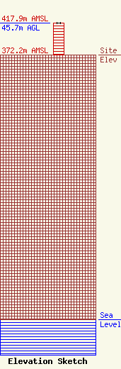
Site Elevation: 372.2 meters (1221 ft) |
| Height of Structure: 45.7 meters (150 feet) |
| Overall Height Above Ground: 45.7 meters (150 feet) |
| Overall Height Above Mean Sea Level: 417.9 meters (1371 feet) |
| Owner Info | American Towers LLC
10 Presidential Way
Woburn, MA 01801
(678) 564-3236
faa-fcc@americantower.com |
| Contact Info | American Towers, LLC
10 Presidential Way
Woburn, MA 01801
(678) 564-3236
faa-fcc@americantower.com |
