|
|
Antenna Structure Registration 1040264 |
 |
Registration Info | Registration Number: 1040264 |
| File Number: A1219654 |
| FAA Study: 2021-ASW-14950-OE |
| FAA Issue Date: 10/19/2021 |
| Status: Constructed |
| Date Constructed: 01/01/1968 |
| NEPA: N |
Structure Info
| Structure Type: GTOWER |
| Structure Coordinates: 31-47-29.3 N 102-35-18.8 W (NAD 83) |
| Structure Coordinates: 31-47-28.8 N 102-35-17.3 W (Converted to NAD 27) |
| Structure Address: 2551 Farm To Market Road 866 (#208199) |
| Structure City: Goldsmith, TX |
| Structure County: Ector County |
| Painting & Lighting Info |
FAA Circular #: 70/7460-1M |
FAA Chapters: 4, 8, 15 |
Remarks: PRIOR STUDY 2013-ASW-2679-OE |
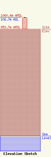
| Elevation Info |
Site Elevation: 953.7 meters (3129 ft) |
| Height of Structure: 103.6 meters (340 feet) |
| Overall Height Above Ground: 106.7 meters (350 feet) |
| Overall Height Above Mean Sea Level: 1060.4 meters (3479 feet) |
| Owner Info | American Towers LLC
10 Presidential Way
Woburn, MA 01801
(781) 926-4500
faa-fcc@americantower.com |
| Contact Info | American Towers LLC
10 Presidential Way
Woburn, MA 01801
(781) 926-4500
faa-fcc@americantower.com |
