|
|
Antenna Structure Registration 1240948 |
 |
Registration Info | Registration Number: 1240948 |
| File Number: A0359915 |
| FAA Study: 2003-ASW-4423-OE |
| FAA Issue Date: 09/15/2003 |
| Status: Constructed |
| Date Constructed: 01/10/2004 |
| FAA EMI: N |
| NEPA: N |
Structure Info
| Structure Type: TOWER |
| Structure Coordinates: 35-25-45.2 N 99-29-49.3 W (NAD 83) |
| Structure Coordinates: 35-25-45.0 N 99-29-48.0 W (Converted to NAD 27) |
| Structure Address: 5.04 Miles Due West Of Elk City Municipal Airport |
| Structure City: Elk City, OK |
| Structure County: Beckham County |
| Painting & Lighting Info |
FAA Circular #: 70/7460-1K |
FAA Chapters: 3, 4, 5, 12 |
Remarks: Removed expiration and final dates from determination. Scenario 2./jjs/case#635066 |
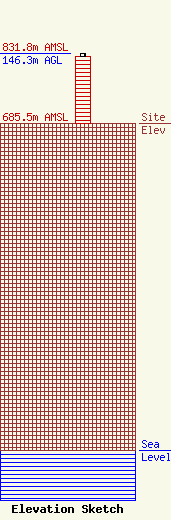
| Elevation Info |
Site Elevation: 685.5 meters (2249 ft) |
| Height of Structure: 140.2 meters (460 feet) |
| Overall Height Above Ground: 146.3 meters (480 feet) |
| Overall Height Above Mean Sea Level: 831.8 meters (2729 feet) |
| Owner Info | Western Communications
PO Box 393
Elk City, OK 73648
Daryle Perry
(580) 225-2294
okcomp@swbell.net |
| Contact Info | Western Communications
PO Box 393
Elk City, OK 73648
Jason Wilhelm
(580) 225-2294
okcomp@swbell.net |
