|
|
Antenna Structure Registration 1040583 |
 |
Registration Info | Registration Number: 1040583 |
| File Number: A1135791 |
| FAA Study: 84-ASW-0941-OE |
| FAA Issue Date: 06/12/1984 |
| Status: Constructed |
| Date Constructed: 06/01/1992 |
| FAA EMI: N |
| NEPA: N |
Structure Info
| Structure Type: TOWER |
| Structure Coordinates: 36-10-48.0 N 94-5-7.0 W (NAD 83) |
| Structure Coordinates: 36-10-47.7 N 94-05-06.3 W (Converted to NAD 27) |
| Structure Address: 417b Carlock Rd |
| Structure City: Springdale, AR |
| Structure County: Washington County |
| Painting & Lighting Info |
FCC Paragraph(s): 1, 3, 12, 21 |
Remarks: RED LIGHTS/PAINT |
| Elevation Info |
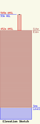
Site Elevation: 452 meters (1483 ft) |
| Height of Structure: 92 meters (302 feet) |
| Overall Height Above Ground: 93 meters (305 feet) |
| Overall Height Above Mean Sea Level: 545 meters (1788 feet) |
| Owner Info | Rox Radio Group, LLC
114 Harrison
Lowell, AR 72745
(479) 770-0111
hecklerkoch91@yahoo.com |
| Contact Info | Law Office of David Tillotson
4606 Charleston Terrace, NW
Washington, DC 20007
David Tillotson
(202) 625-6241
dtlaw67@starpower.net |
