|
|
Antenna Structure Registration 1218064 |
 |
Registration Info | Registration Number: 1218064 |
| File Number: A0217855 |
| FAA Study: 00-ANM-1836-OE |
| FAA Issue Date: 09/29/2000 |
| Status: Constructed |
| Date Constructed: 11/15/2000 |
| FAA EMI: N |
| NEPA: N |
Structure Info
| Structure Type: TOWER |
| Structure Coordinates: 39-13-15.4 N 106-48-49.6 W (NAD 83) |
| Structure Coordinates: 39-13-15.4 N 106-48-47.5 W (Converted to NAD 27) |
| Structure Address: Upper Red Mountain Comm Facility |
| Structure City: Aspen, CO |
| Structure County: Pitkin County |
| Painting & Lighting Info |
FAA Chapters: NONE |
| Elevation Info |
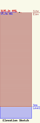
Site Elevation: 3170.1 meters (10401 ft) |
| Overall Height Above Ground: 15.2 meters (50 feet) |
| Overall Height Above Mean Sea Level: 3185.3 meters (10450 feet) |
| Owner Info | County of Pitkin
506 E. Main St. Dept. C
Aspen, CO 81611
(970) 920-5317
markg@co.pitkin.co.us |
| Contact Info | County of Pitkin
506 E. Main St. Dept. C
Aspen, CO 81611
Mark Gamrat
(970) 920-5317
markg@co.pitkin.co.us |
