|
|
Antenna Structure Registration 1032875 |
 |
Registration Info | Registration Number: 1032875 |
| File Number: A1048332 |
| FAA Study: N/A |
| Status: Constructed |
| Date Constructed: 01/01/1991 |
| FAA EMI: N |
| NEPA: N |
Structure Info
| Structure Type: TOWER |
| Structure Coordinates: 46-3-29.0 N 118-22-1.0 W (NAD 83) |
| Structure Coordinates: 46-03-29.5 N 118-21-57.1 W (Converted to NAD 27) |
| Structure Address: 1473 West Rose Street |
| Structure City: Walla Walla, WA |
| Structure County: Walla Walla County |
| Painting & Lighting Info |
FCC Paragraph(s): None |
| Elevation Info |
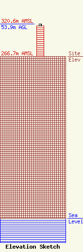
Site Elevation: 266.7 meters (875 ft) |
| Height of Structure: 50.3 meters (165 feet) |
| Overall Height Above Ground: 53.9 meters (177 feet) |
| Overall Height Above Mean Sea Level: 320.6 meters (1052 feet) |
| Info |
| Info |
