|
|
Antenna Structure Registration 1208672 |
 |
Registration Info | Registration Number: 1208672 |
| File Number: A1242702 |
| FAA Study: 2023-AWP-5333-OE |
| FAA Issue Date: 03/22/2023 |
| Status: Constructed |
| Date Constructed: 12/16/1999 |
| NEPA: N |
Structure Info
| Structure Type: LTOWER |
| Structure Coordinates: 36-30-22.7 N 121-43-7.8 W (NAD 83) |
| Structure Coordinates: 36-30-22.8 N 121-43-04.0 W (Converted to NAD 27) |
| Structure Address: End Of Country Club Heights (208250) |
| Structure City: Carmel Valley, CA |
| Structure County: Monterey County |
| Painting & Lighting Info |
FAA Chapters: NONE |
Remarks: PRIOR STUDY 1999-AWP-2085-OE |
| Elevation Info |
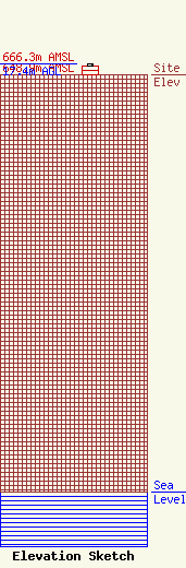
Site Elevation: 648.9 meters (2129 ft) |
| Height of Structure: 12.8 meters (42 feet) |
| Overall Height Above Ground: 17.4 meters (57 feet) |
| Overall Height Above Mean Sea Level: 666.3 meters (2186 feet) |
| Owner Info | American Towers LLC
10 Presidential Way
Woburn, MA 01801
(781) 926-4500
faa-fcc@americantower.com |
| Contact Info | American Towers LLC
10 Presidential Way
Woburn, MA 01801
(781) 926-4500
faa-fcc@americantower.com |
