|
|
Antenna Structure Registration 1060338 |
 |
Registration Info | Registration Number: 1060338 |
| File Number: A1240768 |
| FAA Study: 98-ACE-1353-OE |
| FAA Issue Date: 01/08/1999 |
| Status: Constructed |
| Date Constructed: 05/12/1999 |
| NEPA: N |
Structure Info
| Structure Type: TOWER |
| Structure Coordinates: 37-55-47.0 N 99-20-18.0 W (NAD 83) |
| Structure Coordinates: 37-55-46.9 N 99-20-16.6 W (Converted to NAD 27) |
| Structure Address: 3 3/8 Mi E |
| Structure City: Kinsley, KS |
| Structure County: Edwards County |
| Painting & Lighting Info |
FAA Circular #: 70/7460-1J |
FAA Chapters: 4, 6, 13 |
Remarks: STRUCTURE REACHED GREATEST HEIGHT 5/12/99. |
Remarks: Removed expiration and final dates from determination. Scenario 2./jjs/case#635066 |
Remarks: STRUCTURE REACHED GREATEST HEIGHT 5/12/99. |
Remarks: Removed expiration and final dates from determination. Scenario 2./jjs/case#635066 |
| Elevation Info |
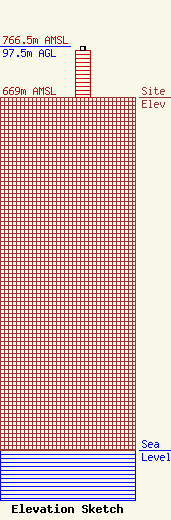
Site Elevation: 669 meters (2195 ft) |
| Height of Structure: 91 meters (299 feet) |
| Overall Height Above Ground: 97.5 meters (320 feet) |
| Overall Height Above Mean Sea Level: 766.5 meters (2515 feet) |
| Owner Info | MRT Communications, Inc.
1844
Great Bend, KS 67530-1844
(402) 466-8188
license@firstwirelessinc.com |
| Contact Info | MRT Communications, Inc.
1844
Great Bend, KS 67530-1844
(402) 466-8188
license@firstwirelessinc.com |
