|
|
Antenna Structure Registration 1059191 |
 |
Registration Info | Registration Number: 1059191 |
| File Number: A0296169 |
| FAA Study: 98-AAL-0082-OE |
| FAA Issue Date: 12/03/1998 |
| Status: Constructed |
| Date Constructed: 12/15/2000 |
| FAA EMI: N |
| NEPA: N |
Structure Info
| Structure Type: POLE |
| Structure Coordinates: 59-13-31.0 N 135-26-49.0 W (NAD 83) |
| Structure Coordinates: 59-13-32.2 N 135-26-42.4 W (Converted to NAD 27) |
| Structure Address: On Chilakat Peninsula 1 Km S |
| Structure City: Haines, AK |
| Structure County: Haines Borough |
| Painting & Lighting Info |
FAA Chapters: NONE |
Remarks: Removed expiration date from determination. Scenario 1./jjs/case#635066 |
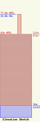
| Elevation Info |
Site Elevation: 61 meters (200 ft) |
| Height of Structure: 16.8 meters (55 feet) |
| Overall Height Above Ground: 16.8 meters (55 feet) |
| Overall Height Above Mean Sea Level: 77.8 meters (255 feet) |
| Owner Info | CITY OF HAINES
1049
HAINES, AK 99827
(907) 766-2121
|
