|
|
Antenna Structure Registration 1052766 |
 |
Registration Info | Registration Number: 1052766 |
| File Number: A1138616 |
| FAA Study: 01-ASW-6901-OE |
| Status: Constructed |
| Date Constructed: 06/11/2002 |
| FAA EMI: N |
| NEPA: N |
Structure Info
| Structure Type: TOWER |
| Structure Coordinates: 32-7-37.0 N 94-47-58.0 W (NAD 83) |
| Structure Coordinates: 32-07-36.4 N 94-47-57.2 W (Converted to NAD 27) |
| Structure Address: 0.4 Miles South Of Johnson On Rayford |
| Structure City: Henderson, TX |
| Structure County: Rusk County |
| Painting & Lighting Info |
FAA Circular #: 70/7460-1K |
FAA Chapters: 3, 4, 5, 12 |
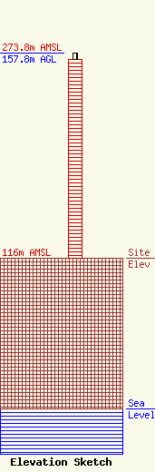
| Elevation Info |
Site Elevation: 116 meters (381 ft) |
| Height of Structure: 153 meters (502 feet) |
| Overall Height Above Ground: 157.8 meters (518 feet) |
| Overall Height Above Mean Sea Level: 273.8 meters (898 feet) |
| Owner Info | Titan Towers, L.P.
6972
Abilene, TX 79602
(325) 691-0495
wharkins@mytitantowers.com |
| Contact Info | Titan Towers, L.P.
6972
Abilene, TX 79602
Warren Harkins
(325) 691-0495
wharkins@mytitantowers.com |
