|
|
Antenna Structure Registration 1015105 |
 |
Registration Info | Registration Number: 1015105 |
| File Number: A1198270 |
| FAA Study: 97-AWP-1369-OE |
| FAA Issue Date: 06/03/1997 |
| Status: Constructed |
| Date Constructed: 03/01/1985 |
| FAA EMI: N |
| NEPA: N |
Structure Info
|
| Structure Coordinates: 40-43-37.0 N 123-58-26.0 W (NAD 83) |
| Structure Coordinates: 40-43-37.5 N 123-58-21.8 W (Converted to NAD 27) |
| Structure Address: 1733 Barry Road |
| Structure City: Kneeland, CA |
| Structure County: Humboldt County |
| Painting & Lighting Info |
FAA Circular #: 70/7460-1J |
FAA Chapters: 3, 4, 5, 13 |
Remarks: PREVIOUS STUDY 84-AWP-4-OE. |
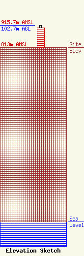
| Elevation Info |
Site Elevation: 813 meters (2667 ft) |
| Height of Structure: 91.4 meters (300 feet) |
| Overall Height Above Ground: 102.7 meters (337 feet) |
| Overall Height Above Mean Sea Level: 915.7 meters (3004 feet) |
| Owner Info | PWM, Inc.
5000 Valleystone Dr., Suite 200
Cary, NC 27519
(919) 653-5700
cdoherty@towerco.com |
| Contact Info | PWM, Inc.
5000 Valleystone Dr., Suite 200
Cary, NC 27519
Chad Doherty
(919) 653-5700
cdoherty@towerco.com |
