|
|
Antenna Structure Registration 1002939 |
 |
Registration Info | Registration Number: 1002939 |
| File Number: A0003308 |
| FAA Study: 79-RM-424-OE |
| FAA Issue Date: 10/24/1979 |
| Status: Constructed |
| Date Constructed: 01/01/1979 |
| NEPA: N |
Structure Info
| Structure Type: TOWER |
| Structure Coordinates: 48-11-9.0 N 105-40-10.0 W (NAD 83) |
| Structure Coordinates: 48-11-08.9 N 105-40-08.0 W (Converted to NAD 27) |
| Structure Address: On Volt Rd 6 Mi N |
| Structure City: Wolf Point, MT |
| Structure County: Roosevelt County |
| Painting & Lighting Info |
FCC Paragraph(s): 1, 3, 12, 21 |
Remarks: RED LIGHTS/PAINT |
| Elevation Info |
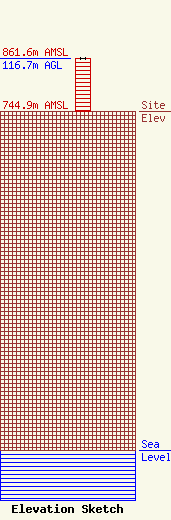
Site Elevation: 744.9 meters (2444 ft) |
| Height of Structure: 115.8 meters (380 feet) |
| Overall Height Above Ground: 116.7 meters (383 feet) |
| Overall Height Above Mean Sea Level: 861.7 meters (2827 feet) |
| Owner Info | WOLF TOWN WIRELESS INC
324 MAIN ST
WOLF POINT, MT 59201
(406) 653-1900
|
