|
|
Antenna Structure Registration 1033922 |
 |
Registration Info | Registration Number: 1033922 |
| File Number: A0040230 |
| FAA Study: 97-ANM-1402-OE |
| FAA Issue Date: 12/08/1997 |
| Status: Granted |
| NEPA: N |
Structure Info
| Structure Type: POLE |
| Structure Coordinates: 48-3-6.0 N 119-42-36.0 W (NAD 83) |
| Structure Coordinates: 48-03-06.5 N 119-42-31.8 W (Converted to NAD 27) |
| Structure Address: Atop Castle Rock 6 Km N |
| Structure City: Bridgeport, WA |
| Structure County: Douglas County |
| Painting & Lighting Info |
FAA Chapters: NONE |
Remarks: Removed expiration date from determination. Scenario 1./jjs/case#635066 |
| Elevation Info |
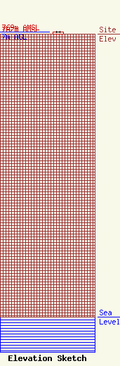
Site Elevation: 762 meters (2500 ft) |
| Height of Structure: 7 meters (23 feet) |
| Overall Height Above Ground: 7 meters (23 feet) |
| Overall Height Above Mean Sea Level: 769 meters (2523 feet) |
| Owner Info | NORTH CASCADES BROADCASTING INC DBA = KOMW AM & FM
151
OMAK, WA 98841
(509) 826-0100
NCBI.NET |
