|
|
Antenna Structure Registration 1200608 |
 |
Registration Info | Registration Number: 1200608 |
| File Number: A0143761 |
| FAA Study: 95-AWP-1859-OE |
| FAA Issue Date: 01/08/1996 |
| Status: Constructed |
| Date Constructed: 01/23/1996 |
| FAA EMI: N |
| NEPA: N |
Structure Info
| Structure Type: TOWER |
| Structure Coordinates: 33-51-58.0 N 116-26-8.0 W (NAD 83) |
| Structure Coordinates: 33-51-57.9 N 116-26-05.0 W (Converted to NAD 27) |
| Structure Address: Edom Hill |
| Structure City: Cathedral City, CA |
| Structure County: Riverside County |
| Painting & Lighting Info |
FAA Chapters: NONE |
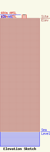
| Elevation Info |
Site Elevation: 465 meters (1526 ft) |
| Height of Structure: 15 meters (49 feet) |
| Overall Height Above Ground: 15 meters (49 feet) |
| Overall Height Above Mean Sea Level: 480 meters (1575 feet) |
| Owner Info | Fisher Wireless Services, Inc.
14530 South Commercial
Blythe, CA 92225
(760) 922-4150
bart@digitaldune.net |
| Contact Info | Lukas, Nace, Gutierrez & Sachs, Chartered
1111 19th Streeet, NW
Washington, DC 20016
Marilyn Mense
(202) 857-3500
mmense@fcclaw.com |
