|
|
Antenna Structure Registration 1023077 |
 |
Registration Info | Registration Number: 1023077 |
| File Number: A1289095 |
| FAA Study: 2002-ACE-2258-OE |
| FAA Issue Date: 11/15/2002 |
| Status: Constructed |
| Date Constructed: 01/01/1996 |
| FAA EMI: N |
| NEPA: N |
Structure Info
| Structure Type: TOWER |
| Structure Coordinates: 37-55-56.0 N 100-19-4.0 W (NAD 83) |
| Structure Coordinates: 37-55-55.9 N 100-19-02.5 W (Converted to NAD 27) |
| Structure Address: 8.8 Mi Ne |
| Structure City: Cimarron, KS |
| Structure County: Gray County |
| Painting & Lighting Info |
FAA Circular #: 70/7460-1K |
FAA Chapters: 3, 4, 5, 12 |
Remarks: PRIOR STUDY 1996-ACE-366-OE |
| Elevation Info |
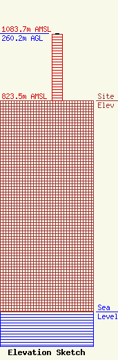
Site Elevation: 823.5 meters (2702 ft) |
| Height of Structure: 259 meters (850 feet) |
| Overall Height Above Ground: 260.2 meters (854 feet) |
| Overall Height Above Mean Sea Level: 1083.7 meters (3555 feet) |
| Owner Info | Kansas Broadcast Company, LLC
2211Stardust Dr.
Clay Center, KS 67432
(785) 632-4828
kbauer@kfrm.com |
| Contact Info | Kansas Broadcast Company, LLC
2211Stardust Dr.
Clay Center, KS 67432
(785) 632-4828
kbauer@kfrm.com |
