|
|
Antenna Structure Registration 1247969 |
 |
Registration Info | Registration Number: 1247969 |
| File Number: A1376789 |
| FAA Study: 2004-ACE-2301-OE |
| FAA Issue Date: 01/13/2005 |
| Status: Constructed |
| Date Constructed: 09/12/2005 |
| FAA EMI: N |
| NEPA: N |
Structure Info
| Structure Type: TOWER |
| Structure Coordinates: 41-4-59.0 N 91-10-19.0 W (NAD 83) |
| Structure Coordinates: 41-04-58.9 N 91-10-18.5 W (Converted to NAD 27) |
| Structure Address: 2 Mi S Int Hwys 22 & 61 |
| Structure City: Wapello, IA |
| Structure County: Louisa County |
| Painting & Lighting Info |
FAA Circular #: 70/7460-1K |
FAA Chapters: 3, 4, 5, 12 |
Remarks: Removed expiration date from determination. Scenario 1./jjs/case#635066 |
| Elevation Info |
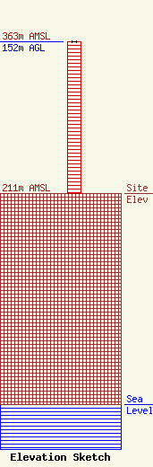
Site Elevation: 211 meters (692 ft) |
| Height of Structure: 152 meters (499 feet) |
| Overall Height Above Ground: 152 meters (499 feet) |
| Overall Height Above Mean Sea Level: 363 meters (1191 feet) |
| Owner Info | K-LOVE, Inc.
2000 Reams Fleming Boulevard
Franklin, TN 37064
(916) 251-1600
fccdocumentdistribution@emfbroadcasting.com |
| Contact Info | K-LOVE, Inc.
2000 Reams Fleming Boulevard
Franklin, TN 37064
(916) 251-1600
fccdocumentdistribution@emfbroadcasting.com |
