|
|
Antenna Structure Registration 1236641 |
 |
Registration Info | Registration Number: 1236641 |
| File Number: A0654173 |
| FAA Study: 2002-ASW-4497-OE |
| FAA Issue Date: 11/01/2002 |
| Status: Constructed |
| Date Constructed: 10/29/2003 |
| FAA EMI: N |
| NEPA: N |
Structure Info
| Structure Type: TOWER |
| Structure Coordinates: 28-46-43.9 N 97-2-51.9 W (NAD 83) |
| Structure Coordinates: 28-46-42.9 N 97-02-50.9 W (Converted to NAD 27) |
| Structure Address: Intersection Of Hwy 59 & Hwy 77 South Of Hwy 59 |
| Structure City: Victoria, TX |
| Structure County: Victoria County |
| Painting & Lighting Info |
FAA Circular #: 70/7460-1K |
FAA Chapters: 4, 6, 12 |
Remarks: PRIOR STUDY 1998-ASW-4271-OE |
| Elevation Info |
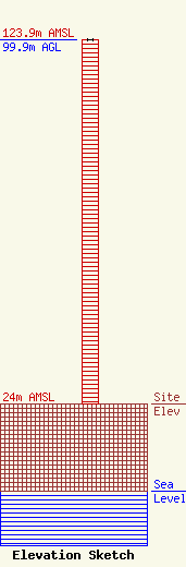
Site Elevation: 24 meters (79 ft) |
| Height of Structure: 99.9 meters (328 feet) |
| Overall Height Above Ground: 99.9 meters (328 feet) |
| Overall Height Above Mean Sea Level: 123.9 meters (406 feet) |
| Owner Info | AMERICAN FAMILY ASSOCIATION
P.O. DRAWER 2440
TUPELO, MS 38803
(662) 844-8888
JES@AFA.NET |
