|
|
Antenna Structure Registration 1025324 |
 |
Registration Info | Registration Number: 1025324 |
| File Number: A1224160 |
| FAA Study: 89-ASW-1862-OE |
| FAA Issue Date: 01/04/1990 |
| Status: Constructed |
| Date Constructed: 01/01/1989 |
| NEPA: N |
Structure Info
| Structure Type: TOWER |
| Structure Coordinates: 35-44-0.0 N 92-15-38.0 W (NAD 83) |
| Structure Coordinates: 35-43-59.7 N 92-15-37.4 W (Converted to NAD 27) |
| Structure Address: Hwy 9 |
| Structure City: Rushing, AR |
| Structure County: Stone County |
| Painting & Lighting Info |
FAA Circular #: 70/7460-1G |
FAA Chapters: 3, 4, 5, 9 |
| Elevation Info |
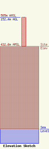
Site Elevation: 432.6 meters (1419 ft) |
| Height of Structure: 152.4 meters (500 feet) |
| Overall Height Above Ground: 152.4 meters (500 feet) |
| Overall Height Above Mean Sea Level: 585 meters (1919 feet) |
| Owner Info | Freedom Broadcasting, Inc.
1061
Fairfield Bay, AR 72088
(501) 884-6812
kffboperations@gmail.com |
| Contact Info | Shainis & Peltzman, Chartered
1850 M Street, NW
Washington, DC 20036
Stephen Lovelady
(202) 293-0011
Steve@s-plaw.com |
