|
|
Antenna Structure Registration 1011586 |
 |
Registration Info | Registration Number: 1011586 |
| File Number: A1380601 |
| FAA Study: 2026-AWP-4353-OE |
| FAA Issue Date: 03/18/2026 |
| Status: Constructed |
| Date Constructed: 10/18/2001 |
| NEPA: N |
Structure Info
| Structure Type: LTOWER |
| Structure Coordinates: 36-12-22.4 N 121-6-52.9 W (NAD 83) |
| Structure Coordinates: 36-12-22.5 N 121-06-49.2 W (Converted to NAD 27) |
| Structure Address: 48448 Lonoak Road (king City #8551) |
| Structure City: King City, CA |
| Structure County: Monterey County |
| Painting & Lighting Info |
FAA Chapters: NONE |
Remarks: PRIOR STUDY 2011-AWP-7001-OE |
| Elevation Info |
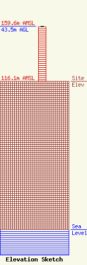
Site Elevation: 116.1 meters (381 ft) |
| Height of Structure: 42.9 meters (141 feet) |
| Overall Height Above Ground: 43.5 meters (143 feet) |
| Overall Height Above Mean Sea Level: 159.6 meters (524 feet) |
| Owner Info | American Towers LLC
10 Presidential Way
Woburn, MA 01801
(781) 926-4500
faa-fcc@americantower.com |
| Contact Info | American Towers LLC
10 Presidential Way
Woburn, MA 01801
(781) 926-4500
faa-fcc@americantower.com |
