|
|
Antenna Structure Registration 1053263 |
 |
Registration Info | Registration Number: 1053263 |
| File Number: A0664948 |
| FAA Study: 2010-ASW-4-OE |
| FAA Issue Date: 06/28/2011 |
| Status: Granted |
| Date Constructed: 01/01/1983 |
| FAA EMI: N |
| NEPA: N |
Structure Info
| Structure Type: TOWER |
| Structure Coordinates: 30-16-24.0 N 93-57-24.0 W (NAD 83) |
| Structure Coordinates: 30-16-23.3 N 93-57-23.4 W (Converted to NAD 27) |
| Structure Address: Site 42 |
| Structure City: Mauriceville, TX |
| Structure County: Jasper County |
| Painting & Lighting Info |
FCC Paragraph(s): 1, 3, 12, 21 |
Remarks: Continue As Is OM&L = PAINT/RED LIGHTS |
Remarks: PRIOR STUDY 1983-ASW-2045-OE |
Remarks: Removed expiration date from determination. Scenario 1./jjs/case#635066 |
Remarks: PRIOR STUDY 1983-ASW-2045-OE |
Remarks: Removed expiration date from determination. Scenario 1./jjs/case#635066 |
Remarks: Continue As Is OM&L = PAINT/RED LIGHTS |
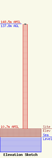
| Elevation Info |
Site Elevation: 10.7 meters (35 ft) |
| Height of Structure: 137 meters (449 feet) |
| Overall Height Above Ground: 137.8 meters (452 feet) |
| Overall Height Above Mean Sea Level: 148.5 meters (487 feet) |
| Owner Info | CCS Radio, Inc.
po box 34321
houston, TX 77234-4321
(832) 721-1101
otis@thegospelhiway.org |
| Contact Info | CCS Radio, Inc.
po box 34321
houston, TX 77234-4321
(832) 721-1101
otis@thegospelhiway.org |
