|
|
Antenna Structure Registration 1019462 |
 |
Registration Info | Registration Number: 1019462 |
| File Number: A0917491 |
| FAA Study: 2011-ASW-1564-OE |
| FAA Issue Date: 03/10/2011 |
| Status: Constructed |
| Date Constructed: 01/01/1986 |
| FAA EMI: N |
| NEPA: N |
Structure Info
| Structure Type: TOWER |
| Structure Coordinates: 30-11-14.7 N 92-37-51.5 W (NAD 83) |
| Structure Coordinates: 30-11-14.0 N 92-37-51.0 W (Converted to NAD 27) |
| Structure Address: 1558 Hwy 1126 |
| Structure City: Jennings, LA |
| Structure County: Jefferson Davis Parish |
| Painting & Lighting Info |
FAA Circular #: 70/7460-1K |
FAA Chapters: 4, 8, 12 |
Remarks: PRIOR STUDY 1989-ASW-431-OE |
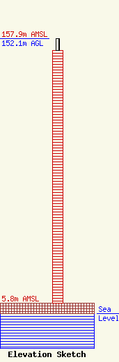
| Elevation Info |
Site Elevation: 5.8 meters (19 ft) |
| Height of Structure: 145.1 meters (476 feet) |
| Overall Height Above Ground: 152.1 meters (499 feet) |
| Overall Height Above Mean Sea Level: 157.9 meters (518 feet) |
| Owner Info | Global Tower, LLC. through American Towers, LLC
10 Presidential Way
Woburn, MA 01801
(678) 564-3236
faa-fcc@americantower.com |
| Contact Info | American Towers, LLC.
10 Presidential Way
Woburn, MA 01801
(678) 564-3236
faa-fcc@americantower.com |
