|
|
Antenna Structure Registration 1024696 |
 |
Registration Info | Registration Number: 1024696 |
| File Number: A0698311 |
| FAA Study: 2010-AGL-1026-OE |
| FAA Issue Date: 05/20/2010 |
| Status: Constructed |
| Date Constructed: 01/01/1997 |
| FAA EMI: N |
| NEPA: N |
Structure Info
| Structure Type: TOWER |
| Structure Coordinates: 46-50-4.7 N 98-41-34.5 W (NAD 83) |
| Structure Coordinates: 46-50-04.8 N 98-41-33.1 W (Converted to NAD 27) |
| Structure Address: 3995 84th Ave Se (nd12258-a) |
| Structure City: Jamestown, ND |
| Structure County: Stutsman County |
| Painting & Lighting Info |
FAA Circular #: 70/7460-1K |
FAA Chapters: 4, 8, 12 |
Remarks: PRIOR STUDY 1997-AGL-1720-OE |
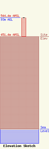
| Elevation Info |
Site Elevation: 451.4 meters (1481 ft) |
| Height of Structure: 91.4 meters (300 feet) |
| Overall Height Above Ground: 93 meters (305 feet) |
| Overall Height Above Mean Sea Level: 544.4 meters (1786 feet) |
| Owner Info | SBA Towers II LLC
8051 Congress Avenue
Boca Raton, FL 33487
(561) 995-7670
ERoach@sbasite.com |
| Contact Info | SBA Towers II LLC
8051 Congress Avenue
Boca Raton, FL 33487
Edward Roach
(561) 995-7670
Eroach@sbasite.com |
