|
|
Antenna Structure Registration 1240833 |
 |
Registration Info | Registration Number: 1240833 |
| File Number: A1376792 |
| FAA Study: 2020-ASW-5415-OE |
| FAA Issue Date: 05/12/2020 |
| Status: Constructed |
| Date Constructed: 07/30/2020 |
| NEPA: N |
Structure Info
| Structure Type: GTOWER |
| Structure Coordinates: 36-42-11.1 N 95-30-57.9 W (NAD 83) |
| Structure Coordinates: 36-42-10.8 N 95-30-57.0 W (Converted to NAD 27) |
| Structure Address: Approximately 0.3 Mi N Of Us Hwy 60 And 1.6 Miles W Of Sh 28, E Of Nowata Ok |
| Structure City: Nowata, OK |
| Structure County: Nowata County |
| Painting & Lighting Info |
FAA Circular #: 70/7460-1K |
FAA Chapters: 3, 4, 5, 12 |
Remarks: OM&L to remain the same as prior study = PAINT/RED LIGHTS |
Remarks: PRIOR STUDY 2003-ASW-3011-OE |
Remarks: OM&L to remain the same as prior study = PAINT/RED LIGHTS |
Remarks: PRIOR STUDY 2003-ASW-3011-OE |
| Elevation Info |
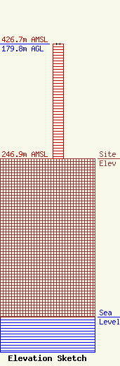
Site Elevation: 246.9 meters (810 ft) |
| Height of Structure: 179.8 meters (590 feet) |
| Overall Height Above Ground: 179.8 meters (590 feet) |
| Overall Height Above Mean Sea Level: 426.7 meters (1400 feet) |
| Owner Info | K-LOVE, Inc.
2000 Reams Fleming Boulevard
Franklin, TN 37064
(916) 251-1600
fccdocumentdistribution@emfbroadcasting.com |
| Contact Info | K-LOVE, Inc.
2000 Reams Fleming Boulevard
Franklin, TN 37064
(916) 251-1600
fccdocumentdistribution@emfbroadcasting.com |
