|
|
Antenna Structure Registration 1239653 |
 |
Registration Info | Registration Number: 1239653 |
| File Number: A0910268 |
| FAA Study: 2014-ANM-1710-OE |
| FAA Issue Date: 07/21/2014 |
| Status: Constructed |
| Date Constructed: 05/14/2004 |
| FAA EMI: N |
| NEPA: N |
Structure Info
| Structure Type: GTOWER |
| Structure Coordinates: 45-45-54.8 N 108-27-19.2 W (NAD 83) |
| Structure Coordinates: 45-45-55.0 N 108-27-16.7 W (Converted to NAD 27) |
| Structure Address: Colburn Hill 2.6 Mi Ese (mt15943-t Tower 3) |
| Structure City: Billings, MT |
| Structure County: Yellowstone County |
| Painting & Lighting Info |
FAA Circular #: 70/7460-1K |
FAA Chapters: 4, 8, 12 |
Remarks: PRIOR STUDIES 2014-ANM-1206-OE / 2003-ANM-475-OE |
Remarks: OM&L to remain the same as prior studies = A MED-DUAL SYSTEM |
Remarks: PRIOR STUDIES 2014-ANM-1206-OE / 2003-ANM-475-OE |
Remarks: OM&L to remain the same as prior studies = A MED-DUAL SYSTEM |
| Elevation Info |
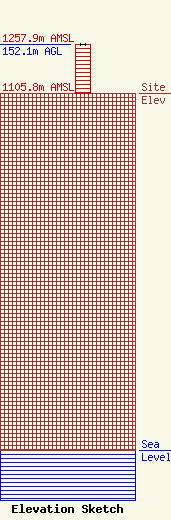
Site Elevation: 1105.8 meters (3628 ft) |
| Height of Structure: 151 meters (495 feet) |
| Overall Height Above Ground: 152.1 meters (499 feet) |
| Overall Height Above Mean Sea Level: 1257.9 meters (4127 feet) |
| Owner Info | SBA GC Towers, LLC
8051 Congress Avenue
Boca Raton, FL 33487
(561) 995-7670
ERoach@sbasite.com |
| Contact Info | SBA GC Towers, LLC
8051 Congress Avenue
Boca Raton, FL 33487
(561) 995-7670
ERoach@sbasite.com |
