|
|
Antenna Structure Registration 1041531 |
 |
Registration Info | Registration Number: 1041531 |
| File Number: A0196034 |
| FAA Study: 90-ASW-0343-OE |
| FAA Issue Date: 05/31/1990 |
| Status: Granted |
| Date Constructed: 01/01/1990 |
| NEPA: N |
Structure Info
| Structure Type: TOWER |
| Structure Coordinates: 31-25-17.0 N 100-32-37.0 W (NAD 83) |
| Structure Coordinates: 31-25-16.4 N 100-32-35.7 W (Converted to NAD 27) |
| Structure Address: 4 Miles West Of San Angelo Tx |
| Structure City: San Angelo, TX |
| Structure County: Tom Green County |
| Painting & Lighting Info |
FAA Circular #: 70/7460-1G |
FAA Chapters: 3, 4, 5, 9 |
| Elevation Info |
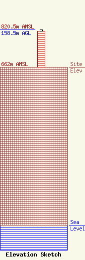
Site Elevation: 662 meters (2172 ft) |
| Height of Structure: 152.4 meters (500 feet) |
| Overall Height Above Ground: 158.5 meters (520 feet) |
| Overall Height Above Mean Sea Level: 820.5 meters (2692 feet) |
| Owner Info | WILBUR L ANDERSON DBA WESTERN TOWERS
320 WEST 26TH ST
PO BOX 2040
SAN ANGELO, TX 76902-2040
(915) 658-6539
|
