|
|
Antenna Structure Registration 1023116 |
 |
Registration Info | Registration Number: 1023116 |
| File Number: A1153591 |
| FAA Study: 2010-AGL-2346-OE |
| FAA Issue Date: 06/20/2010 |
| Status: Constructed |
| Date Constructed: 10/07/2010 |
| FAA EMI: N |
| NEPA: N |
Structure Info
| Structure Type: TOWER |
| Structure Coordinates: 45-32-40.8 N 92-58-20.4 W (NAD 83) |
| Structure Coordinates: 45-32-40.9 N 92-58-19.6 W (Converted to NAD 27) |
| Structure Address: 0.3 Miles East On Cr 30 410th Street |
| Structure City: North Branch, MN |
| Structure County: Chisago County |
| Painting & Lighting Info |
FAA Circular #: 70/7460-1K |
FAA Chapters: 4, 8, 12 |
Remarks: PRIOR STUDY 2003-AGL-353-OE |
Remarks: OM&L to remain the same as prior study = A MED-DUAL SYSTEM |
Remarks: PRIOR STUDY 2003-AGL-353-OE |
Remarks: OM&L to remain the same as prior study = A MED-DUAL SYSTEM |
| Elevation Info |
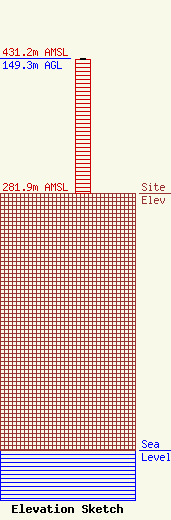
Site Elevation: 281.9 meters (925 ft) |
| Height of Structure: 147.8 meters (485 feet) |
| Overall Height Above Ground: 149.3 meters (490 feet) |
| Overall Height Above Mean Sea Level: 431.2 meters (1415 feet) |
| Owner Info | Cellco Partnership
5055 North Point Pkwy
Alpharetta, GA 30022
(770) 797-1070
Network.Regulatory@verizonwireless.com |
| Contact Info | Cellco Partnership
5055 North Point Pkwy
Alpharetta, GA 30022
Regulatory Manager
(770) 797-1070
Network.Regulatory@verizonwireless.com |
