|
|
Antenna Structure Registration 1013606 |
 |
Registration Info | Registration Number: 1013606 |
| File Number: A1282312 |
| FAA Study: 90-AWP-177-OE |
| FAA Issue Date: 07/05/1990 |
| Status: Constructed |
| Date Constructed: 01/01/1990 |
| FAA EMI: N |
| NEPA: N |
Structure Info
| Structure Type: TOWER |
| Structure Coordinates: 34-17-3.0 N 118-28-20.0 W (NAD 83) |
| Structure Coordinates: 34-17-03.0 N 118-28-16.7 W (Converted to NAD 27) |
| Structure Address: 15600 1/2 Odyssey Dr |
| Structure City: Granada Hills, CA |
| Structure County: Los Angeles County |
| Painting & Lighting Info |
FCC Paragraph(s): A1, H |
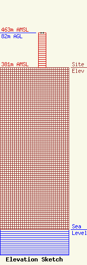
| Elevation Info |
Site Elevation: 381 meters (1250 ft) |
| Height of Structure: 82 meters (269 feet) |
| Overall Height Above Ground: 82 meters (269 feet) |
| Overall Height Above Mean Sea Level: 463 meters (1519 feet) |
| Owner Info | MediaCo Operations LLC
48 West 25th Street
New York, NY 10010
(202) 663-8167
scott.flick@pillsburylaw.com |
| Contact Info | Pillsbury Winthrop Shaw Pittman LLP
1200 Seventeenth Street, NW
Washington, DC 20036
Scott Flick
(202) 663-8167
scott.flick@pillsburylaw.com |
