|
|
Antenna Structure Registration 1048460 |
 |
Registration Info | Registration Number: 1048460 |
| File Number: A1284544 |
| FAA Study: 2024-ASW-4818-OE |
| FAA Issue Date: 05/09/2024 |
| Status: Constructed |
| Date Constructed: 10/03/1981 |
| NEPA: N |
Structure Info
| Structure Type: GTOWER |
| Structure Coordinates: 31-22-1.6 N 100-2-49.9 W (NAD 83) |
| Structure Coordinates: 31-22-01.0 N 100-02-48.6 W (Converted to NAD 27) |
| Structure Address: 3.3 Mi Se Of Eola, Tx |
| Structure City: Eola, TX |
| Structure County: Concho County |
| Painting & Lighting Info |
FAA Circular #: 70/7460-1M |
FAA Chapters: 4, 7, 15 |
Remarks: PRIOR STUDY 2009-ASW-1254-OE |
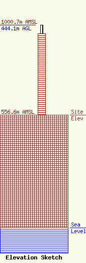
| Elevation Info |
Site Elevation: 556.6 meters (1826 ft) |
| Height of Structure: 401 meters (1316 feet) |
| Overall Height Above Ground: 444.1 meters (1457 feet) |
| Overall Height Above Mean Sea Level: 1000.7 meters (3283 feet) |
| Owner Info | Nexstar Media Inc.
545 E. John Carpenter Freeway
Irving, TX 75062
(972) 373-8800
jasroberts@nexstar.tv |
| Contact Info | Nexstar Media Inc.
545 E. John Carpenter Freeway
Irving, TX 75062
Jason Roberts
(972) 373-8800
jasroberts@nexstar.tv |
